August 28, 2026

7 minutes read

7 minutes read

By

Cycle routes from Engel Obertal

Four routes, from a panoramic loop to the Tour de Murg. And the hotel's own e-bike fleet for a tailwind.

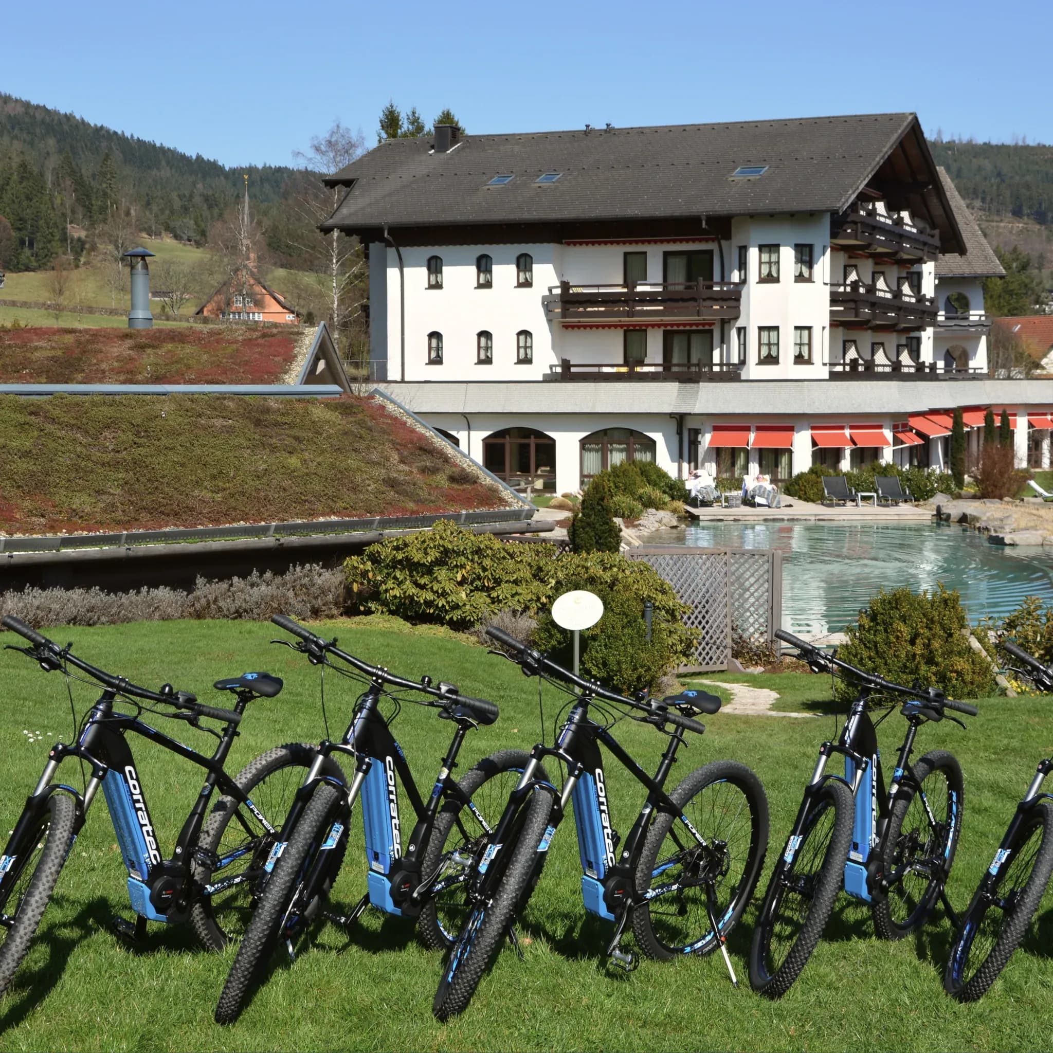
Reihe blauer E-Bikes auf der Wiese vor dem Hotel mit Naturpool.

Around Obertal, every bike ride takes you out into nature, for leisurely riders and ambitious ones alike. Mountains and valleys, glacial lakes and rivers, the heights of the national park and the wide Murg valley all begin right outside the hotel door.

Here we introduce four routes. Three upland loops of between 28 and 43 kilometres, well within reach on an e-bike even for leisurely riders, and the well-known Tour de Murg, which rolls downstream as far as the Rhine valley. Each route comes with a map and an elevation profile.

The right bike, by the way, is already waiting at the hotel. Our fleet includes hardtail and full-suspension e-mountain bikes from Trek with 12-speed gears, available for a fee and reserved at reception.

Zuflucht-Ruhestein tour, the national park loop

28.6 kilometres · moderate · 506 metres of ascent · around 3 hours

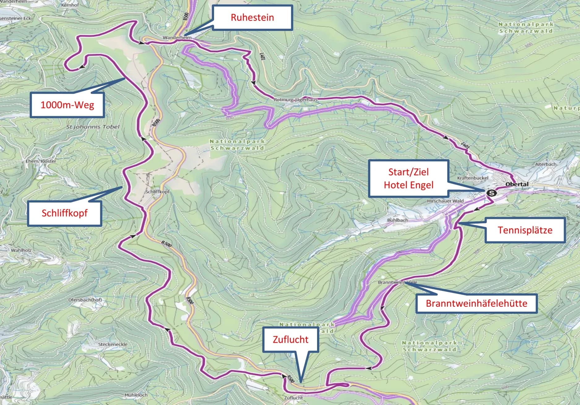
From the hotel, the route leads via the Weiher towards Buhlbachsaue and past the minigolf course and the outdoor pool to the tennis courts. Then the climb begins. Following the T8 up to the Branntweinhäfelehütte with its view over Obertal, then along the tarmac Weiherhaldesträßle through the national park to the B500 and the Zuflucht.

From here the T9 passes the Lotharpfad on its way to the Schliffkopf, with its viewing platform at the Steinmäuerle, then continues along the 1000-Meter-Weg, with wide views into the Rhine valley, to the Ruhestein. Rolling downhill straight past the national park centre, the T4 takes you back to Obertal via the "Steine erzählen Geschichte" discovery trail (stones tell history).

Radtourenkarte der Zuflucht-Ruhestein-Runde ab Hotel Engel Obertal mit Route über Branntweinhäfelehütte, Zuflucht, Schliffkopf und Ruhestein.

The Zuflucht-Ruhestein loop crosses the Schliffkopf and follows the 1000-Meter-Weg through the national park.
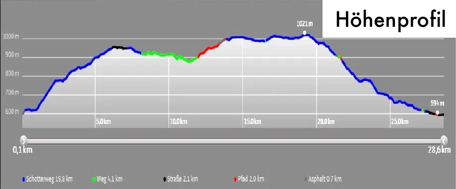
Höhenprofil der Zuflucht-Ruhestein-Radtour: 28,6 km, 506 Höhenmeter.

Elevation profile of the Zuflucht-Ruhestein tour, 506 metres of ascent.
T4-Ruhestein tour, through three valleys

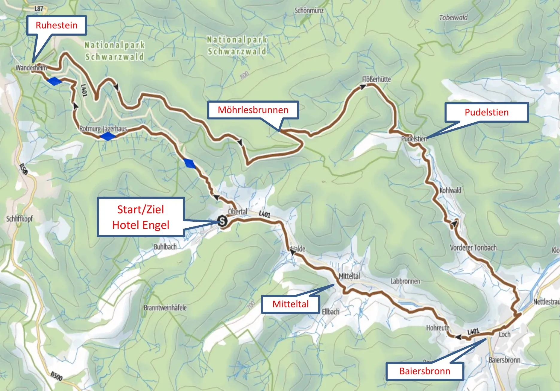
37.8 kilometres · moderate · 603 metres of ascent · around 4 hours

At the Rotmurg signpost, a waymarked gravel track sets off along the Rotmurg and carries you right up to the Ruhestein. The final stretch is a steep unsurfaced path that asks for one last push of stamina.

North of the Ruhesteinstraße, the route winds along the hillside on broad gravel tracks towards Neuberg and the Möhrlesbrunnen, the source of the Tonbach. The tour then follows the stream down the valley, past the original charcoal kiln behind the Wiesenhütte, to Baiersbronn and back via Mitteltal to Obertal.

Radtourenkarte der T4-Ruhestein-Runde ab Hotel Engel Obertal mit Route über Ruhestein, Möhrlesbrunnen, Tonbachtal und Baiersbronn.

The T4 loop, up the Rotmurg valley and down the Tonbach valley.
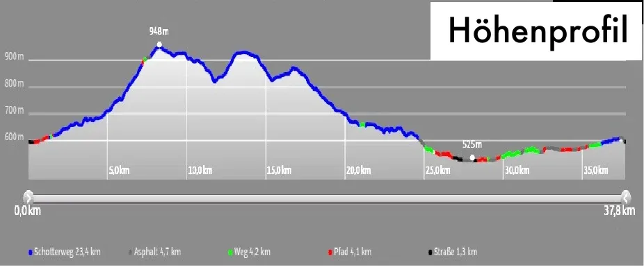
Höhenprofil der T4-Ruhestein-Radtour: 37,8 km, 603 Höhenmeter.

Elevation profile of the T4-Ruhestein tour, 603 metres of ascent, the hilliest of the four routes.

“On an e-bike, 600 metres of climbing turn into kilometres to savour. The Trek fleet is kept right here at the hotel.”
Schwarzwaldhochstraße tour, the big panoramic loop

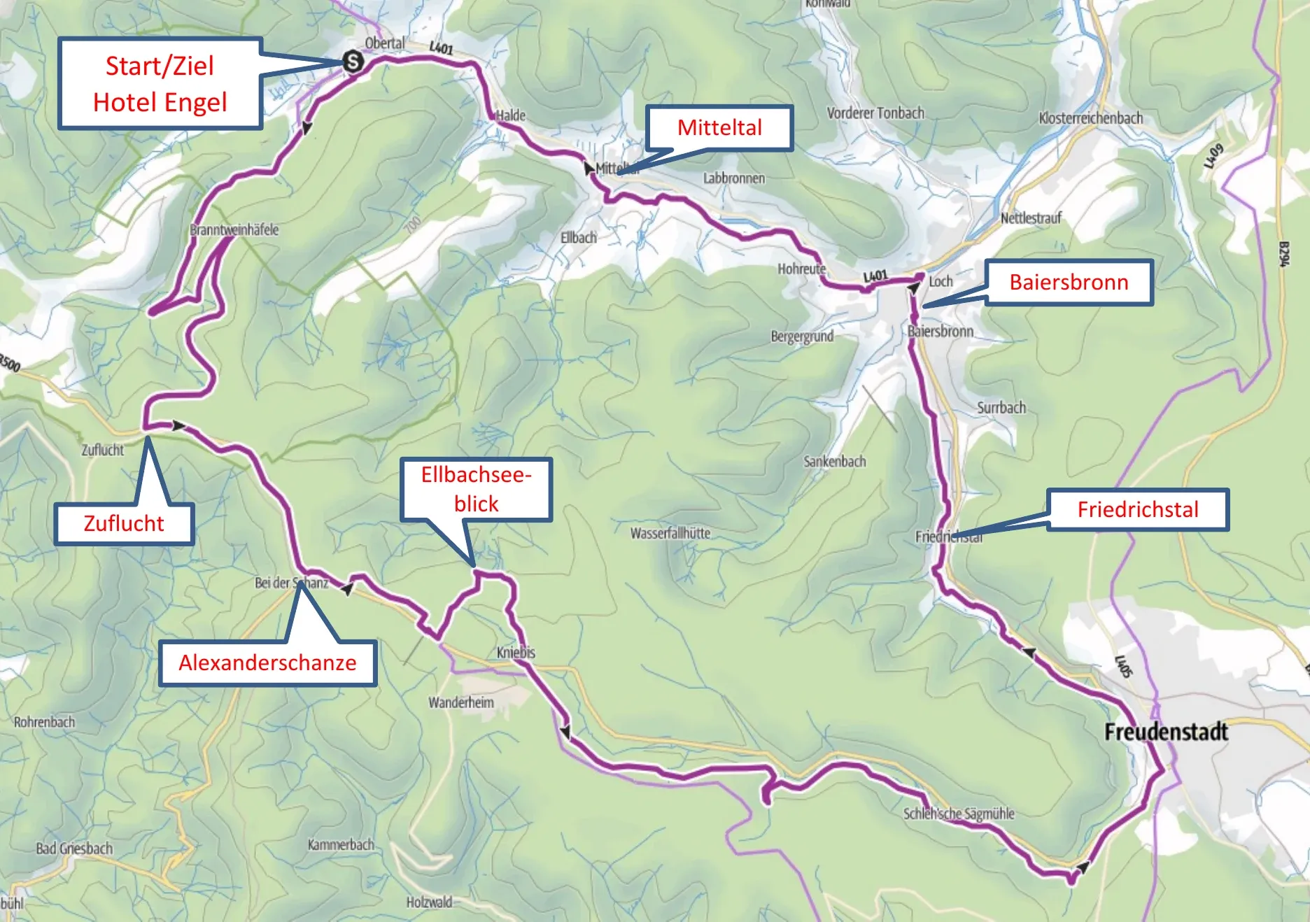
42.7 kilometres · moderate · 507 metres of ascent · around 4 hours

Via the Weiher, the tennis courts and the Lärchenhütte car park, the long and scenic climb begins on the Schwarzwald-Radweg up to the Schwarzwaldhochstraße, the Black Forest High Road. From the Bärenteichhütte, a detour to the Buhlbachsee is worthwhile. By way of Zuflucht and Alexanderschanze you reach Kniebis, where a sweeping view awaits, over the Ellbachsee and across Mitteltal to the Hornisgrinde.

Through the Forbach valley, the route passes the Langenbrunnenweiher on the way to the Langenwaldsee and crosses the Bässler Brücke into Freudenstadt. From there you follow the Tour de Murg through Christophstal and Friedrichstal to Baiersbronn, then ride along the Murg via Mitteltal back to Obertal.

Radtourenkarte der Schwarzwaldhochstraße-Runde ab Hotel Engel Obertal mit Route über Zuflucht, Alexanderschanze, Kniebis und Freudenstadt.

The Schwarzwaldhochstraße loop, 42.7 kilometres via Kniebis and Freudenstadt.
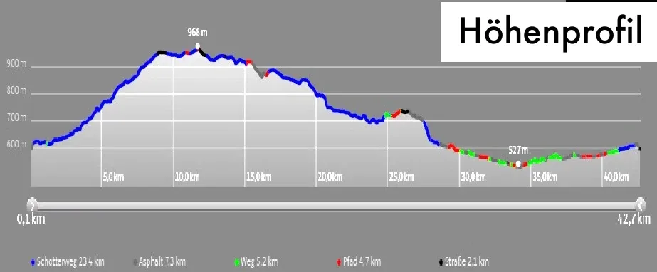
Höhenprofil der Schwarzwaldhochstraße-Radtour: 42,7 km, 507 Höhenmeter.

Elevation profile of the Schwarzwaldhochstraße tour, 507 metres of ascent.
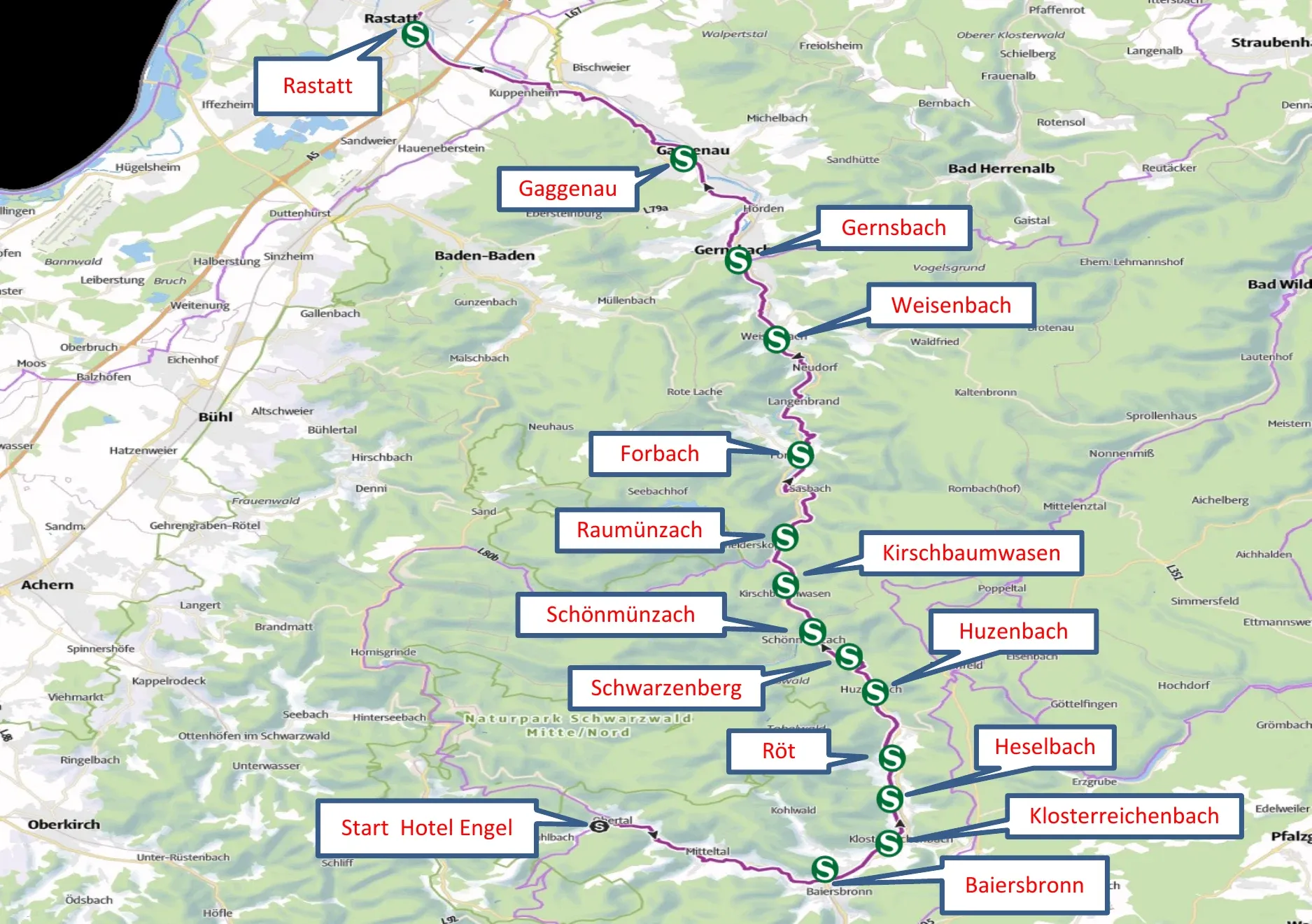
Tour de Murg, downstream to the Rhine valley

35 kilometres to Forbach or 67 kilometres to Rastatt · easy · 84 metres of ascent · 3 to 6 hours

The Murg valley cycle route is the northern Black Forest's easy-going classic. Barely 100 metres of climbing, spread over short stretches, put the tour within reach of occasional cyclists and families too, and heading downstream the gradient gives you a noticeable push. Through the raftsmen's forest, the route rolls past magnolias, chestnut trees and broadleaf woods all the way to the Rhine valley.

From the hotel, head past the Obertal tourist information office into the Kurpark, then simply follow the "Tour de Murg" signs. Thanks to the S-Bahn in the Murg valley, you can cut the tour short at Klosterreichenbach, Häselbach, Röt, Huzenbach, Schwarzenberg or Forbach. With the Konus guest card, the journey back is free of charge, and the timetable is available at reception.

Radtourenkarte der Tour de Murg von Obertal durchs Murgtal bis Forbach und Rastatt mit S-Bahn-Rückfahrmöglichkeiten.

The Tour de Murg follows the river from Obertal to Rastatt, and the S-Bahn brings you back.
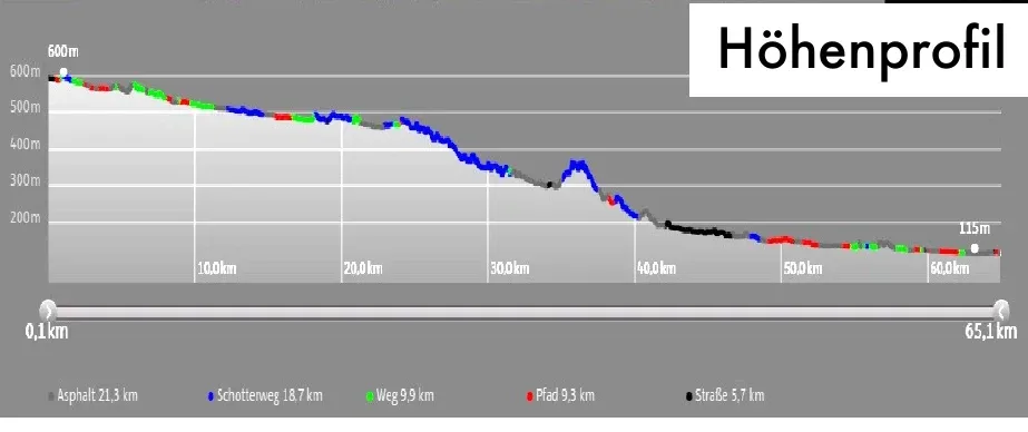
Höhenprofil der Tour de Murg: 67 km talabwärts, nur 84 Höhenmeter Aufstieg bei 560 Metern Abstieg.

Elevation profile of the Tour de Murg, 560 metres downhill, only 84 uphill.

Good to know

The three upland loops run mostly on gravel and forest tracks. On the hardtail or full-suspension e-mountain bikes from Trek in our fleet, they are a pleasure even without any competitive ambitions. It is best to reserve your bike at reception when you arrive. There is a charge for using them.

Helmets, maps and tips on choosing a route are also available at the hotel, and for the Tour de Murg the current S-Bahn timetable comes with them.

Aktiv

Further reading

Related articles

  • Tennisspieler beim Aufschlag auf einem Sandplatz, von oben fotografiert, mit langen Schatten auf dem Platz.

    Engel Obertal

    September 29, 2026

    Tennis at Engel Obertal

    Three clay courts in the Buhlbach valley, around 15 minutes on foot from the hotel. Guests of the Engel can play at the Tennisgemeinschaft Obertal, the local tennis club.
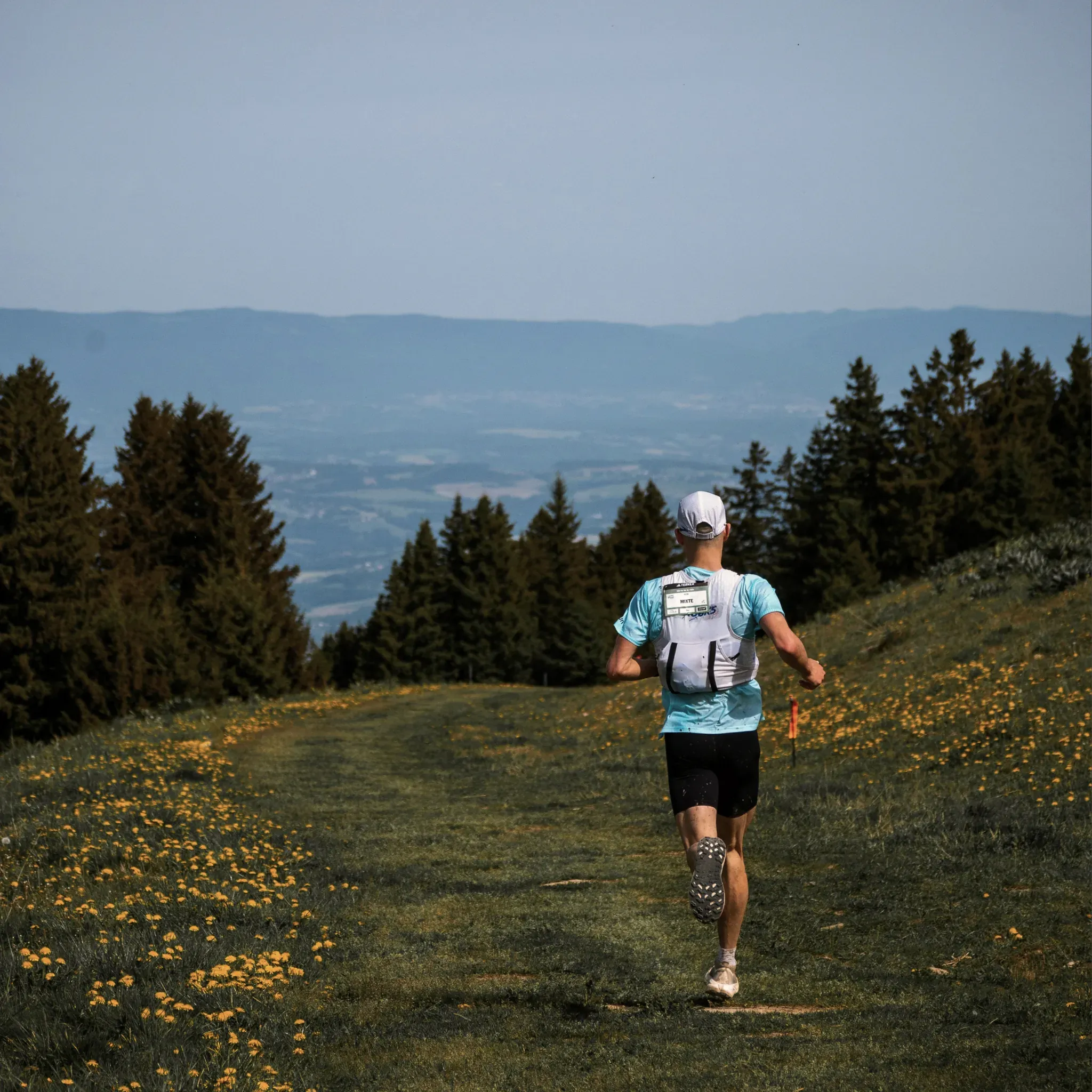
  • Läufer mit Trinkweste joggt über eine blühende Bergwiese am Waldrand.

    Engel Obertal

    August 25, 2026

    Running routes at Engel Obertal

    Four loops between 2.7 and 8.2 kilometres. An easy morning run at one end, a demanding forest loop at the other.
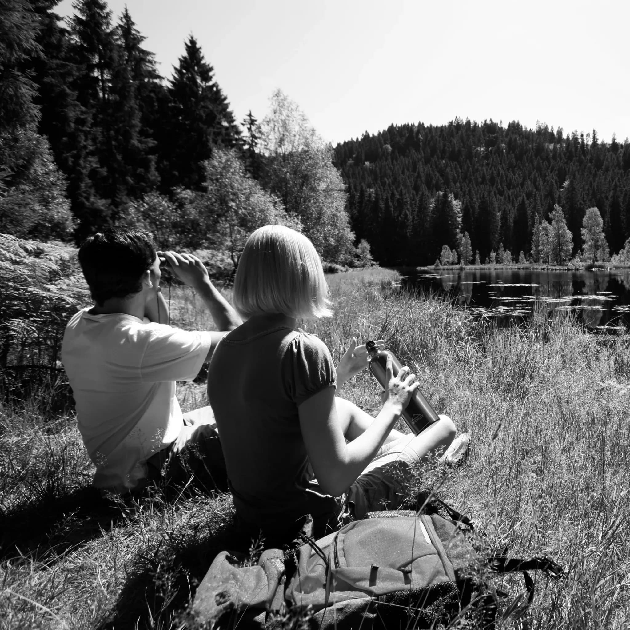
  • Zwei Wanderer machen Rast am Ufer eines von Wald umschlossenen Sees, Schwarzweiß.

    Engel Obertal

    August 21, 2026

    Long hikes into the Rotmurg valley, to the Rechtmurg and up to the Buhlbachsee

    Three circular routes of over ten kilometres for anyone who wants a full day's walking. All the way to a dark tarn.

  • Tennisspieler beim Aufschlag auf einem Sandplatz, von oben fotografiert, mit langen Schatten auf dem Platz.

    Engel Obertal

    September 29, 2026

    Tennis at Engel Obertal

    Three clay courts in the Buhlbach valley, around 15 minutes on foot from the hotel. Guests of the Engel can play at the Tennisgemeinschaft Obertal, the local tennis club.

  • Läufer mit Trinkweste joggt über eine blühende Bergwiese am Waldrand.

    Engel Obertal

    August 25, 2026

    Running routes at Engel Obertal

    Four loops between 2.7 and 8.2 kilometres. An easy morning run at one end, a demanding forest loop at the other.

  • Zwei Wanderer machen Rast am Ufer eines von Wald umschlossenen Sees, Schwarzweiß.

    Engel Obertal

    August 21, 2026

    Long hikes into the Rotmurg valley, to the Rechtmurg and up to the Buhlbachsee

    Three circular routes of over ten kilometres for anyone who wants a full day's walking. All the way to a dark tarn.

  • Tennisspieler beim Aufschlag auf einem Sandplatz, von oben fotografiert, mit langen Schatten auf dem Platz.

    Engel Obertal

    September 29, 2026

    Tennis at Engel Obertal

    Three clay courts in the Buhlbach valley, around 15 minutes on foot from the hotel. Guests of the Engel can play at the Tennisgemeinschaft Obertal, the local tennis club.

  • Läufer mit Trinkweste joggt über eine blühende Bergwiese am Waldrand.

    Engel Obertal

    August 25, 2026

    Running routes at Engel Obertal

    Four loops between 2.7 and 8.2 kilometres. An easy morning run at one end, a demanding forest loop at the other.

  • Zwei Wanderer machen Rast am Ufer eines von Wald umschlossenen Sees, Schwarzweiß.

    Engel Obertal

    August 21, 2026

    Long hikes into the Rotmurg valley, to the Rechtmurg and up to the Buhlbachsee

    Three circular routes of over ten kilometres for anyone who wants a full day's walking. All the way to a dark tarn.