August 14, 2026

6 minutes read

6 minutes read

By

Easy hikes around Obertal

Three leisurely walks right on the hotel doorstep. Hirschauer Wald, Heilklimaweg Buhlbachtal and Terrainkurweg Ilgenbachtal.

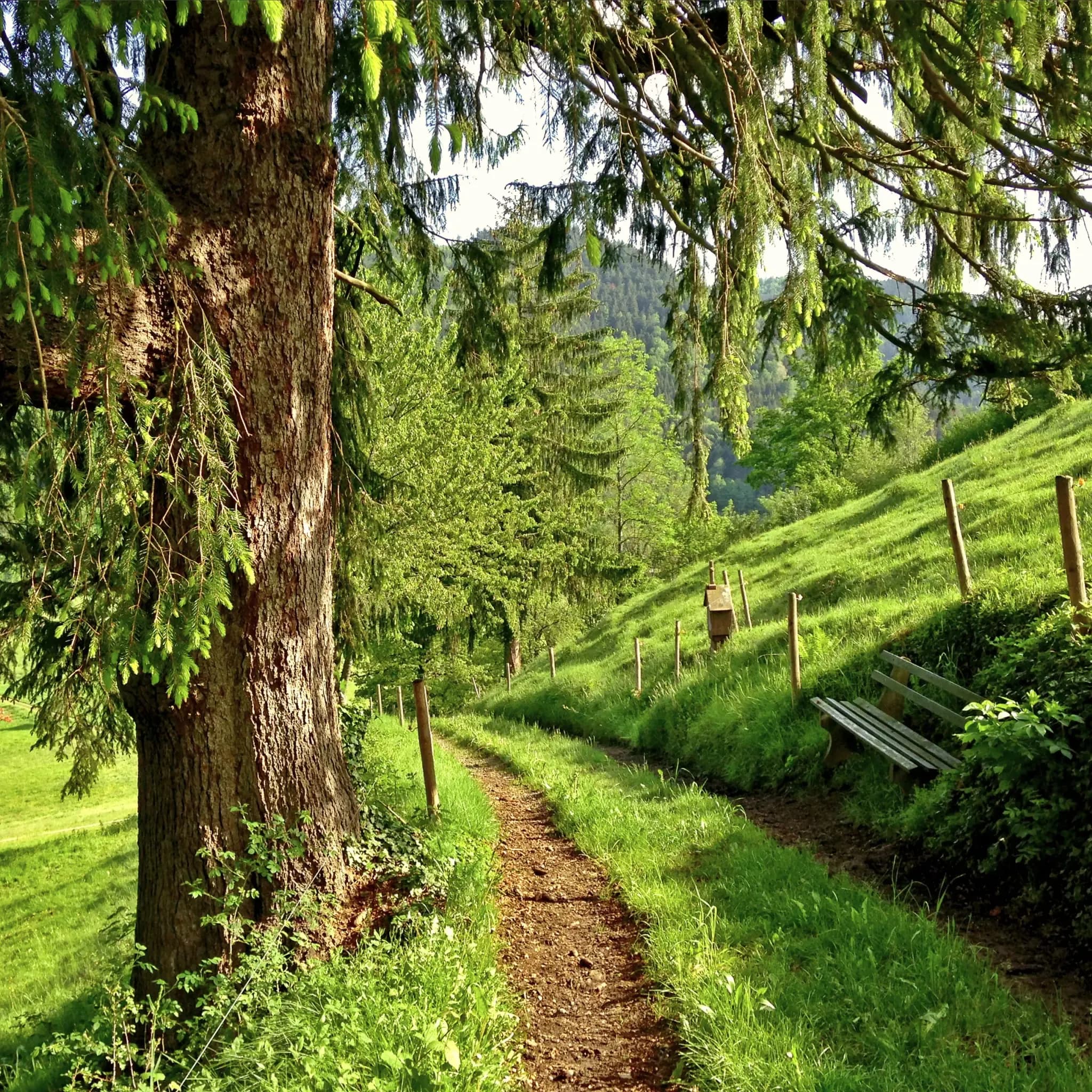
Schmaler Wanderweg mit Holzbank führt einen bewaldeten Hang entlang.

Not every hike has to be an assault on a summit. Around Obertal, several circular routes begin right at the Engel's door, and they offer a genuine experience of nature without demanding much in the way of fitness. Well-made paths, moderate gradients and fine views over the Rechtmurg valley at every turn.

Here we present three easy routes of between five and six and a half kilometres in detail, each with a map and elevation profile. All three start and finish at the Hotel Engel, so there is no need to drive anywhere first.

Hirschauer Wald, the loop along the forest edge

5.0 kilometres · easy · 120 metres of ascent · around 1 hour 30 minutes

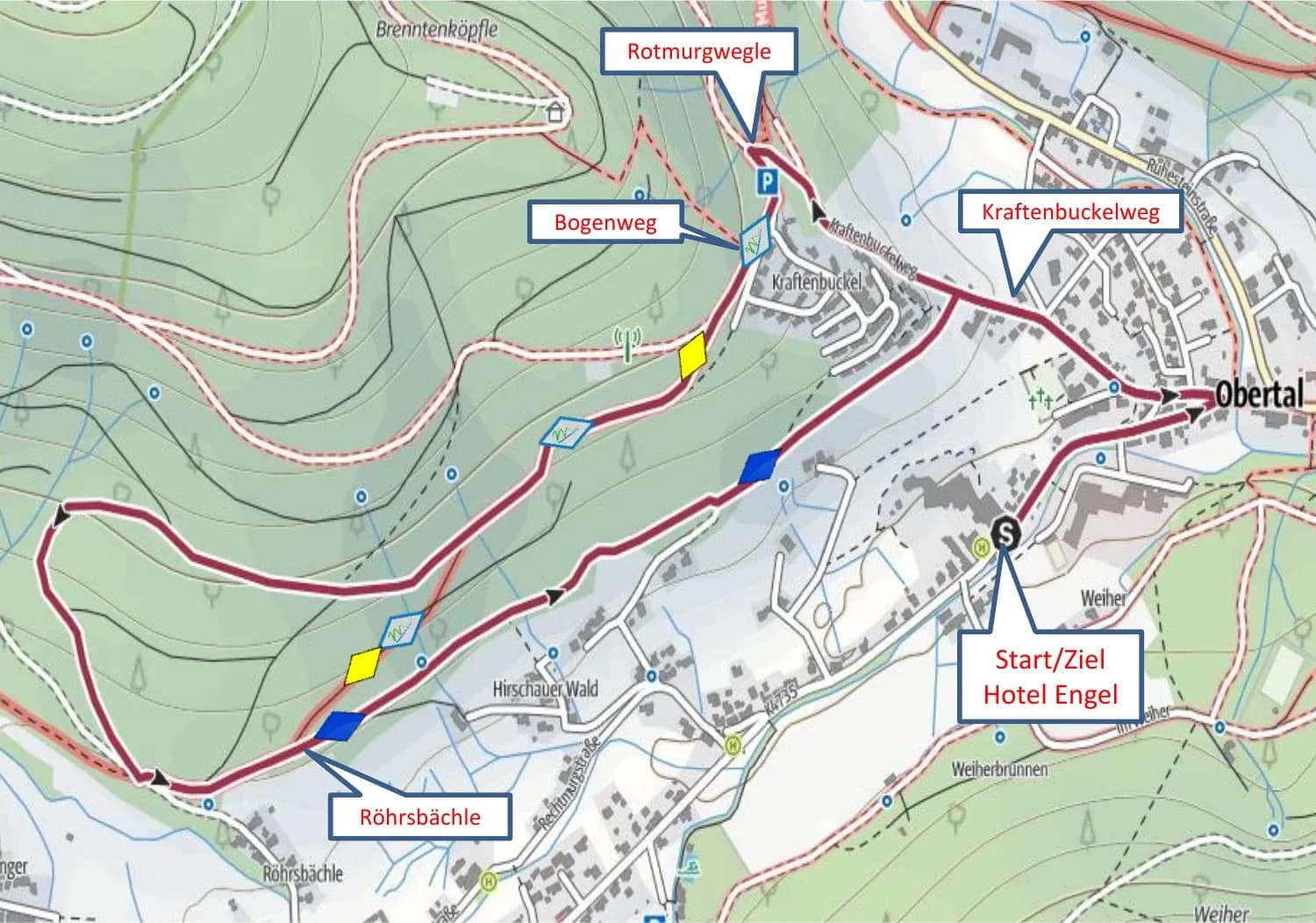
From the hotel, follow the Rechtmurgstraße and take the path opposite the sanatorium up to the Protestant church. The Kraftenbuckelweg brings you to the Rotmurgwegle signpost, where you follow the signs towards Kraftenbuckel and Bogenweg, first for a stretch along the Murgleiter, then along the yellow diamond waymarks.

The broad forest track takes you at an unhurried pace past the Röhrsbächle stream and then along the edge of the woods above Obertal, with the valley in view the whole time. This forest-edge stretch eventually rejoins the Kraftenbuckelweg, and from there it is downhill back to the Engel.

Wanderkarte der Tour Hirschauer Wald ab Hotel Engel Obertal mit eingezeichneter Route über Kraftenbuckelweg, Bogenweg und Röhrsbächle.

The route through the Hirschauer Wald, 5 kilometres along the forest edge above Obertal.
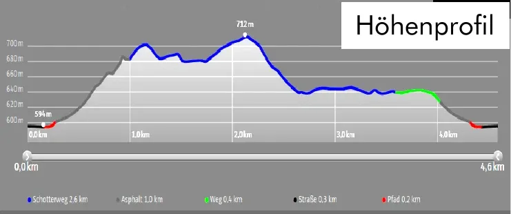
Höhenprofil der Wanderung Hirschauer Wald: 5,0 km, 120 Höhenmeter, höchster Punkt 712 m.

Elevation profile of the Hirschauer Wald loop, a gentle climb to 712 metres, then an easy return.
Heilklimaweg Buhlbachtal, deep breaths in the bracing air

5.7 kilometres · easy · 89 metres of ascent · around 1 hour 30 minutes

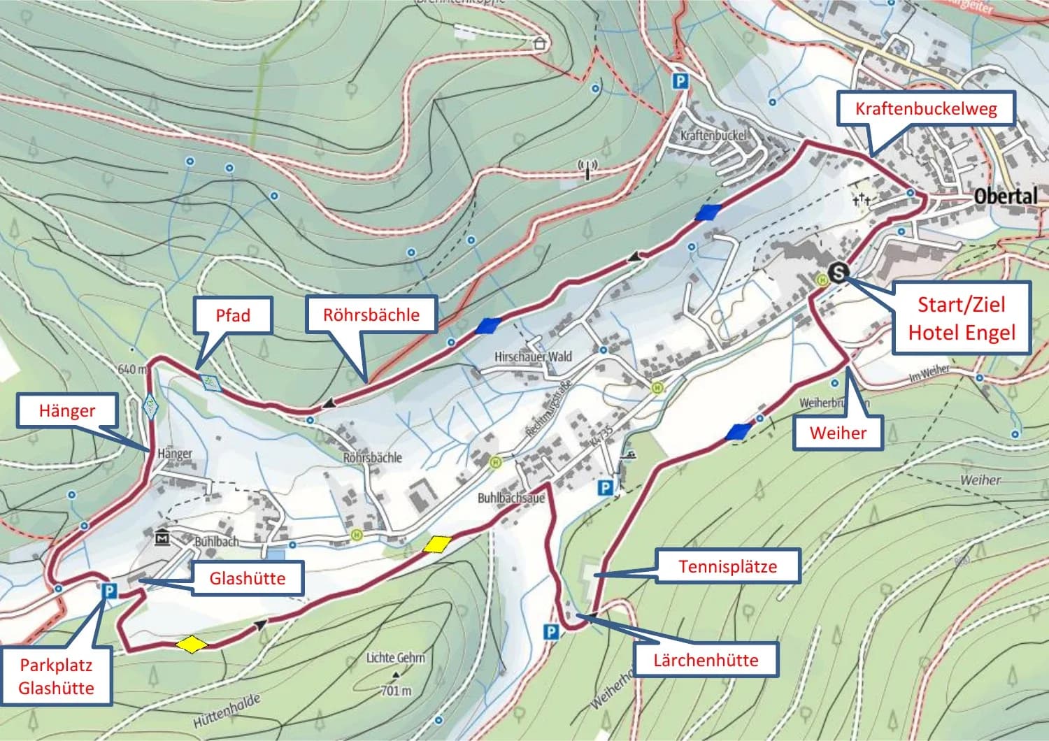
Baiersbronn is a climatic health resort, and this path lets you experience the principle for yourself, walking at a deliberate, measured pace in the clear valley air. From the hotel, the route follows the Kraftenbuckelweg past the Protestant church and then runs along the fringe of the woods, keeping to the blue diamond waymarks as far as the Röhrsbächle.

An unsurfaced stretch of the Murgleiter trail brings you to the Hänger signpost and on to the Glashütte car park. Right by the Glashütte, cross a bridge and climb across the meadow to where the trees begin, then follow the yellow diamonds towards the Buhlbachsee as far as the Lärchenhütte. From there you pass the tennis courts and stroll back along the woodland edge to the Hotel Engel.

Wanderkarte des Heilklimawegs durchs Buhlbachtal ab Hotel Engel Obertal mit eingezeichneter Route über Röhrsbächle, Hänger und Glashütte.

The Heilklimaweg through the Buhlbach valley, a figure of eight through meadows and along the edge of the forest.
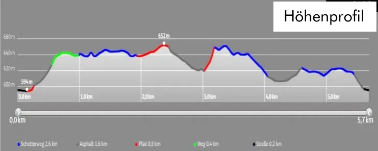
Höhenprofil des Heilklimawegs Buhlbachtal: 5,7 km, 89 Höhenmeter.

Elevation profile of the Heilklimaweg, only 89 metres of ascent, ideal for breathing deeply.

“Three circular routes, no driving at all. All the routes begin and end right outside the Engel's front door.”
Terrainkurweg Ilgenbachtal, the loop to savour

6.5 kilometres · easy · 101 metres of ascent · around 1 hour 45 minutes

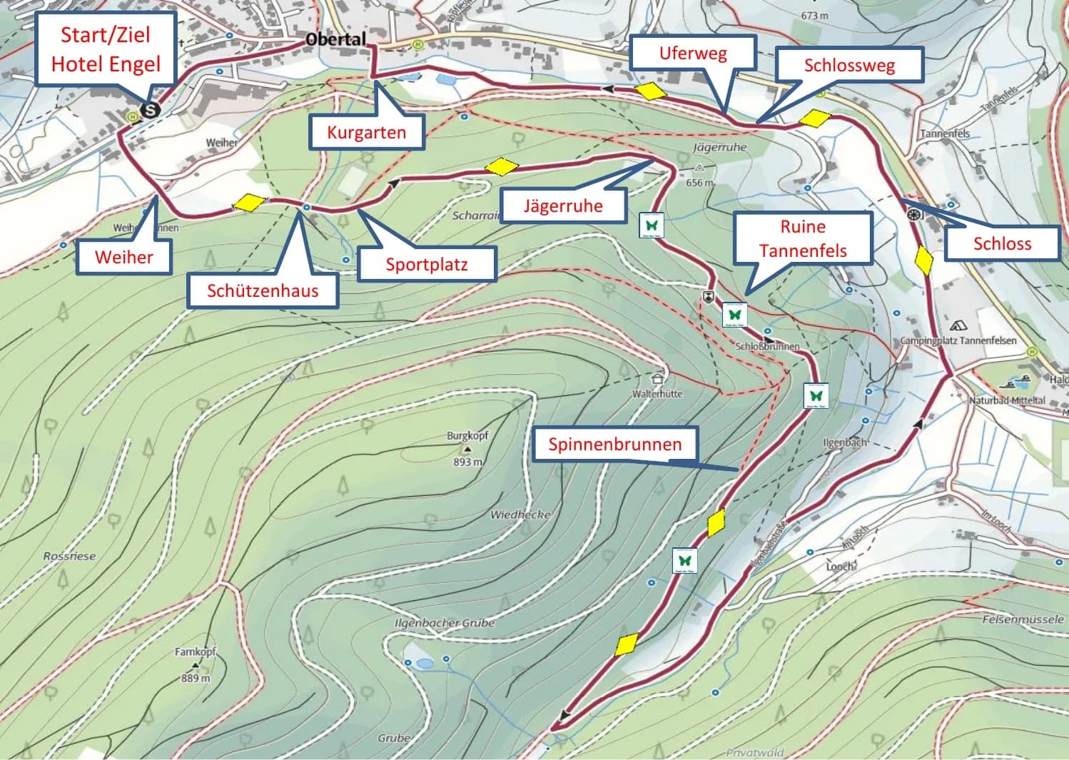
The longest of the three easy loops leads from the hotel towards the Buhlbach valley and up the Weiherweg to the Schützenhaus in the woods. From there the yellow diamonds take you over fairly level ground to the sports ground and the Jägerruhe, then along the Genießer-Tour trail, to the right above the Tannenfels ruins and past the Försterstein to the Spinnenbrunnen.

The way back runs along the Ilgenbachstraße to just short of the Naturbad Mitteltal natural swimming pool, then follows the yellow diamonds past the Schloss, Schlossweg and Uferweg signposts to the Kurgarten. Opposite the Kneipp basin you cross the little bridge, pass the tourist information office in Obertal and shortly afterwards find yourself back in front of the Engel.

Wanderkarte des Terrainkurwegs durchs Ilgenbachtal ab Hotel Engel Obertal mit Route über Schützenhaus, Jägerruhe, Ruine Tannenfels und Kurgarten.

The Terrainkurweg through the Ilgenbach valley, returning via the Kurgarten and the Uferweg.
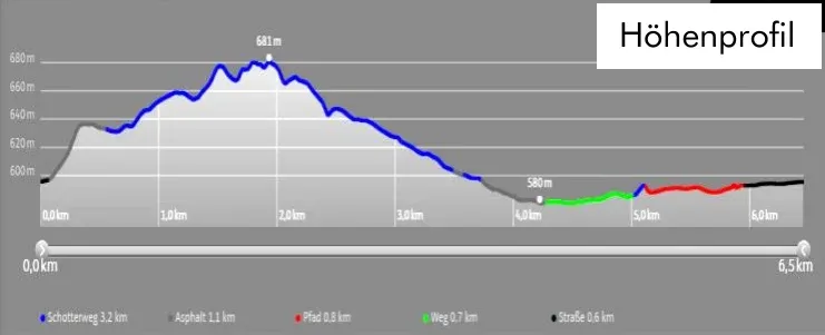
Höhenprofil des Terrainkurwegs Ilgenbachtal: 6,5 km, 101 Höhenmeter.

Elevation profile of the Terrainkurweg, a gentle arc with 101 metres of ascent.

Good to know

All three routes follow the signposting of the Baiersbronner Wanderhimmel, Baiersbronn's hiking network. Blue and yellow diamonds mark the way, and the signpost boards at the junctions make it easy to find your bearings. Hiking rucksacks and walking poles can be borrowed free of charge from our reception.

If you would rather plan the routes digitally, the free Nationalparkregion app shows every path around Obertal on a topographic map, complete with route planner and current notices. And if you still have energy left after the walk, it is only a few steps to the sauna at Wolke 7.

Aktiv

Further reading

Related articles

  • Tennisspieler beim Aufschlag auf einem Sandplatz, von oben fotografiert, mit langen Schatten auf dem Platz.

    Engel Obertal

    September 29, 2026

    Tennis at Engel Obertal

    Three clay courts in the Buhlbach valley, around 15 minutes on foot from the hotel. Guests of the Engel can play at the Tennisgemeinschaft Obertal, the local tennis club.
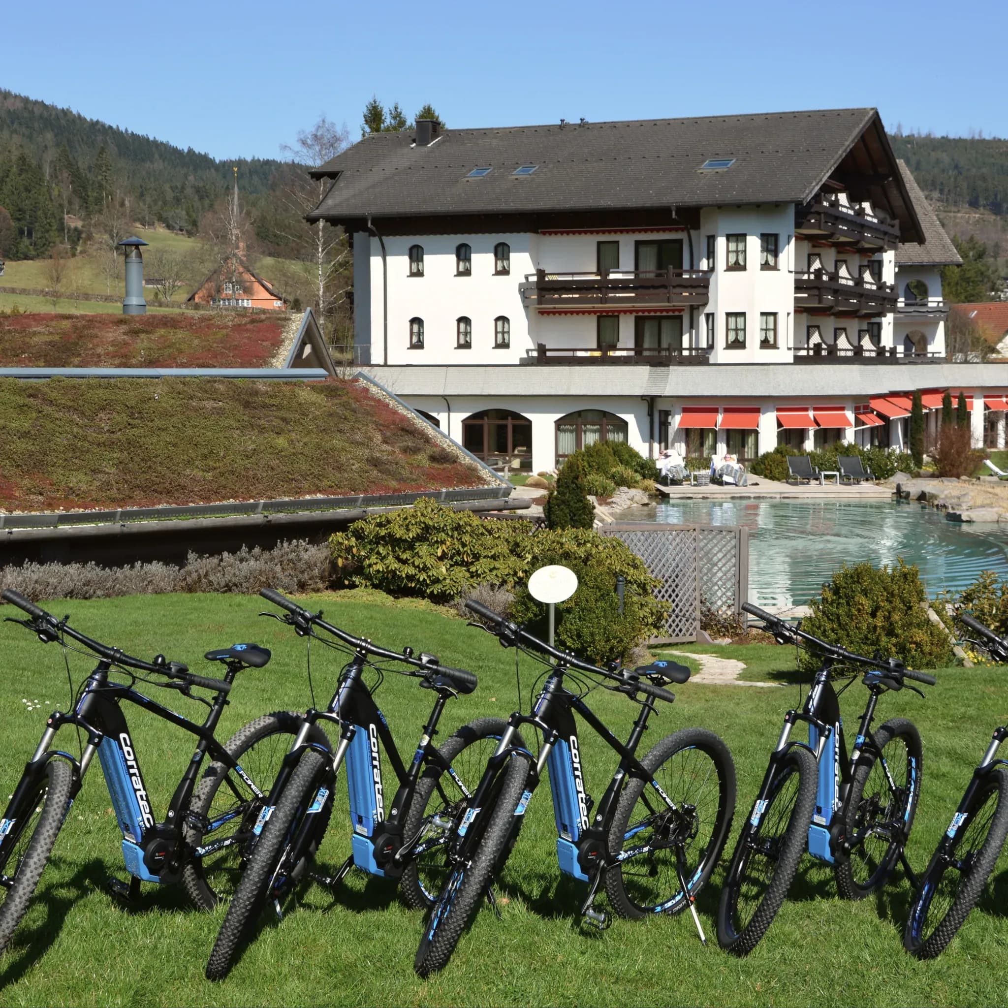
  • Reihe blauer E-Bikes auf der Wiese vor dem Hotel mit Naturpool.

    Engel Obertal

    August 28, 2026

    Cycle routes from Engel Obertal

    Four routes, from a panoramic loop to the Tour de Murg. And the hotel's own e-bike fleet for a tailwind.
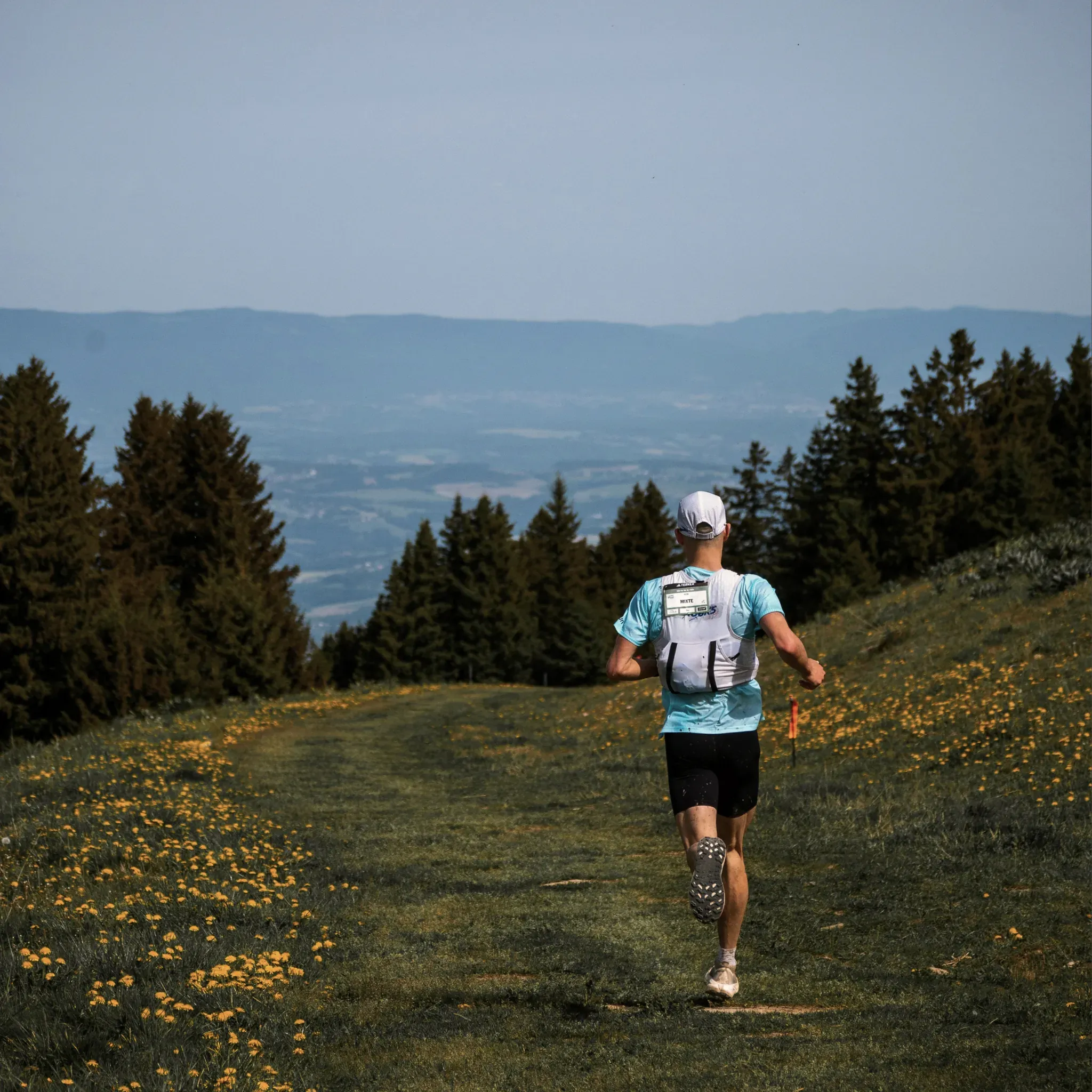
  • Läufer mit Trinkweste joggt über eine blühende Bergwiese am Waldrand.

    Engel Obertal

    August 25, 2026

    Running routes at Engel Obertal

    Four loops between 2.7 and 8.2 kilometres. An easy morning run at one end, a demanding forest loop at the other.

  • Tennisspieler beim Aufschlag auf einem Sandplatz, von oben fotografiert, mit langen Schatten auf dem Platz.

    Engel Obertal

    September 29, 2026

    Tennis at Engel Obertal

    Three clay courts in the Buhlbach valley, around 15 minutes on foot from the hotel. Guests of the Engel can play at the Tennisgemeinschaft Obertal, the local tennis club.

  • Reihe blauer E-Bikes auf der Wiese vor dem Hotel mit Naturpool.

    Engel Obertal

    August 28, 2026

    Cycle routes from Engel Obertal

    Four routes, from a panoramic loop to the Tour de Murg. And the hotel's own e-bike fleet for a tailwind.

  • Läufer mit Trinkweste joggt über eine blühende Bergwiese am Waldrand.

    Engel Obertal

    August 25, 2026

    Running routes at Engel Obertal

    Four loops between 2.7 and 8.2 kilometres. An easy morning run at one end, a demanding forest loop at the other.

  • Tennisspieler beim Aufschlag auf einem Sandplatz, von oben fotografiert, mit langen Schatten auf dem Platz.

    Engel Obertal

    September 29, 2026

    Tennis at Engel Obertal

    Three clay courts in the Buhlbach valley, around 15 minutes on foot from the hotel. Guests of the Engel can play at the Tennisgemeinschaft Obertal, the local tennis club.

  • Reihe blauer E-Bikes auf der Wiese vor dem Hotel mit Naturpool.

    Engel Obertal

    August 28, 2026

    Cycle routes from Engel Obertal

    Four routes, from a panoramic loop to the Tour de Murg. And the hotel's own e-bike fleet for a tailwind.

  • Läufer mit Trinkweste joggt über eine blühende Bergwiese am Waldrand.

    Engel Obertal

    August 25, 2026

    Running routes at Engel Obertal

    Four loops between 2.7 and 8.2 kilometres. An easy morning run at one end, a demanding forest loop at the other.